
This post has been read 6047 times!
 March 1, 2013 By Steven E. Greer
BatteryPark.TV was the only local news site operational and reporting updates on the status of the flooding as the Hurricane Sandy storm surge came and went, leaving BPC virtually unscathed (see video below). Many readers were incredulous when they read our headline “Hurricane Sandy: Battery Park unscathed compared to rest of New York“. Months later, most people still have no idea that BPC was safe from the flood water and power outages. The region has been lumped in with the devastation of nearby FiDi, Tribeca, and the Seaport.
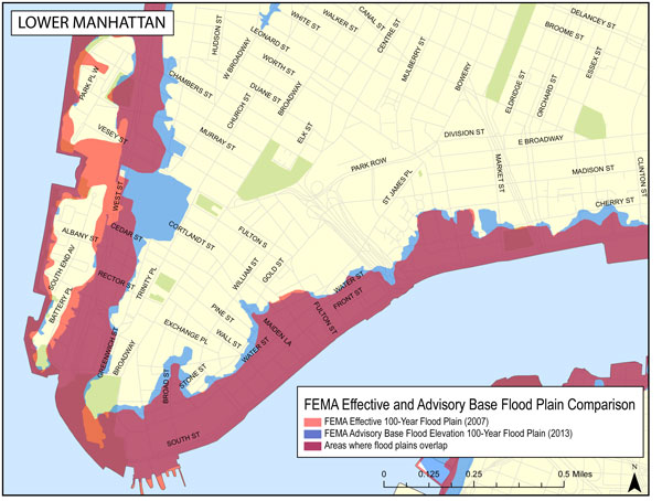
Now, new flood zone maps have been drafted by FEMA and the insurance industry is recognizing that Battery Park City is in fact of lower risk that the other areas, according to Downtown Express. In the map, above, the orange areas from 2007 estimates seem to no longer be making the cut in 2013, which is an improvement for BPC.
Excerpts from Downtown Express: “The map is for insurance purposes only and does not relate to the city’s evacuation maps… A spokesperson for the city’s Office of Emergency Management said the FEMA map will not affect the evacuation map. At a briefing Feb. 26 with FEMA, Dep. Mayor Cas Holloway said it would take about two years to finalize the new map…..The maps show the probability of a flood in any given year. Advisory Zone V could be flooded by high velocity, breaking waves of three feet or more. Buildings in this zone must be elevated over an open foundation so that waves can break under them…..In Zone A, flooding from storm surges can be expected. The lowest floors of buildings in this zone should be used for parking and building access, with utilities raised above the base floor elevation or otherwise flood-proofed.”
It’s alive! BP.TV rises from dead on Halloween
Hurricane Sandy: Battery Park unscathed compared to rest of New York
New York magazine cover of Manhattan half dark
A humanitarian crisis is brewing as electronic refugees come to BPC for power
Count our blessings: Nearby South Street Seaport mostly destroyed
New York magazine cover of Manhattan half dark

Thank you for continuing to provide relevant information to the BPC community!